Tadcaster Flood Alleviation Scheme Proposals
Results updated 4 Jul 2023
Dear Tadcaster, please see the attached results from our recent public enagegement around the Tadcaster Flood Alleviation Scheme and Fish pass. We do wish to thank everyone who took part, and helped us run the consultation. Your views are important to us as we progress the scheme.
Files:
- Consultation Summary, 889.0 KB (PDF document)
Published responses
View submitted responses where consent has been given to publish the response.
Overview
We would like to share with you our proposals for the Tadcaster Flood Alleviation Scheme, and the Tadcaster weir fish pass. This scheme aims to enhance and upgrade the current flood defences, better protecting homes and businesses from flooding whilst also improving the water environment creating benefits for wildlife.

More Information
The brewery town of Tadcaster is located on the River Wharfe and has grown over time due to the availability of water and access to the river network. However, this location also has a history of flooding which is often devastating for the residents and businesses in the community. The River Wharfe catchment is of considerable size covering an area of approximately 1000 km2, equivalent to around 11’000 football pitches. High rainfall further up this large catchment area can have a big impact on Tadcaster as it eventually finds its way into the River Wharfe and therefore straight through the town.

More Information
Tadcaster’s existing flood defences were constructed in the 1980's and are a combination of raised earth embankments and flood walls along both banks of the River Wharfe. There are also numerous 'Ings' located within the river catchment area, all designed to assist with river management during high water levels. Whilst these defences continue to offer some protection to Tadcaster, climate change is increasing the frequency and severity of heavy rainfall. The town has suffered several flooding events, the most recent in February 2022 and flooding on Boxing Day 2015 which contributed to the bridge connecting both sides of the town failing.
Our proposals
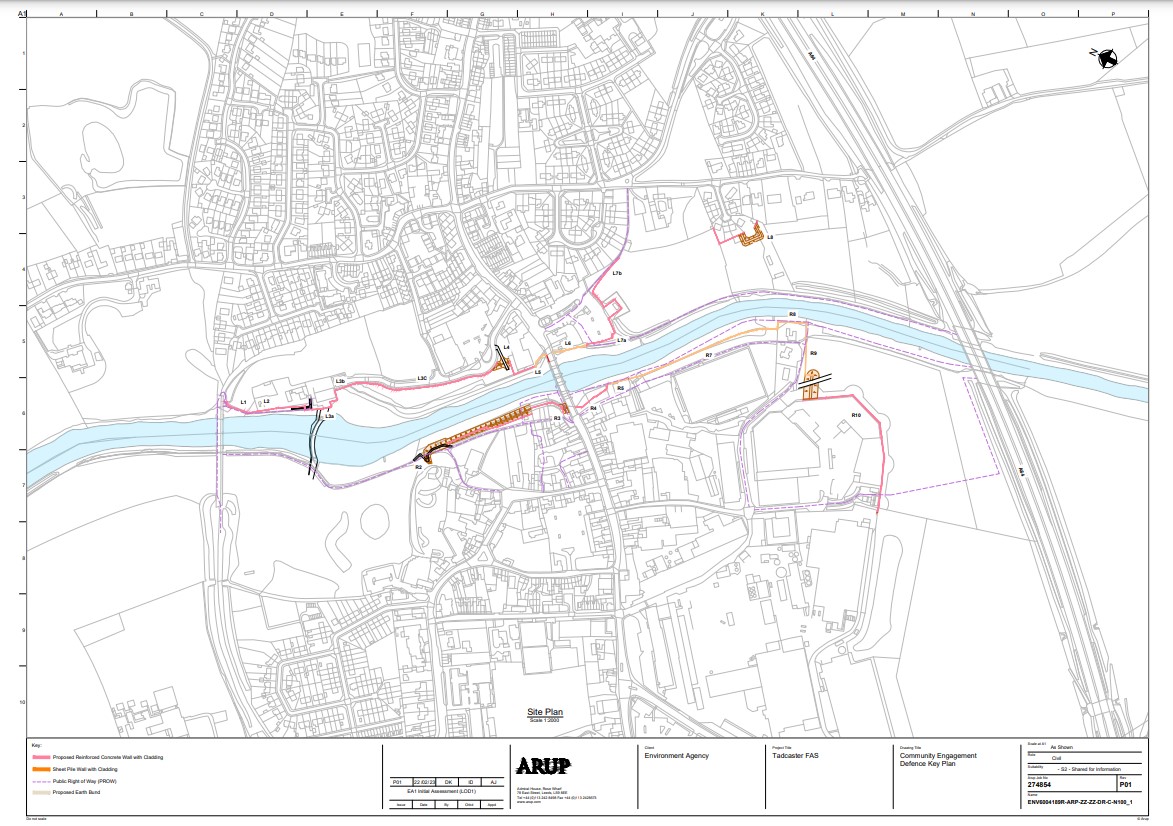
Our proposals will reduce flood risk to residents and businesses. We want to create new defences, as well as raise and improve existing defences, whilst ensuring the scheme is in keeping with the local area. The design of the whole scheme aims to fit within the sensitive site context as well as increasing the level of flood protection. Wherever possible, we aim to minimise negative impacts on the landscape and views, the setting of the Conservation Area and historic structures through careful design and choice of materials, alongside integrated landscaping and planting schemes.
We plan to defend Tadcaster against flooding to a defence level of 1 in a 100-year event, plus climate change (predicted to 2050). The height of proposed defences varies due to factors affecting river dynamics such as tidal influence, wind direction, and obstacles such as the bridge and weir; more detail can be found on the following plans and visualisations. (More can be found within the sections and also at the bottom of the page).

Defences along the east bank would be constructed using masonry clad sheet piles, bunds, and walls. Where possible, defences would be enhanced with brick or stone cladding to sympathetically blend in with the surroundings along this embankment.
The defence line starts from the viaduct, in front of Mill Lane where it meets the bridge. The defences would then run around the medical centre, bus station and Britannia car park, following the existing defence line towards Ouston Lane. There would also be some additional defences created to protect properties at risk of flooding in the Beech Close area.
More Information
The west bank defences would run from the riverfront area at St Mary's church, along Wharfe Bank Terrace where it meets the bridge, continuing along the edge of the football field, around Crane Cottages towards the Ings. Downstream of the bridge the defence line would follow the current line of defences.
This stretch of defences would also comprise a variety of bunds, masonry clad sheet piles and retaining walls. We are keen to ensure the areas around the church and surrounding historic properties not only benefit from a greater level of flood defence but also retains their special character; with this in mind we aim to minimise wherever possible any visual impact in this particular location.
More Information
What will the defences look like?
As mentioned previously, the design of the whole scheme aims to fit within the sensitive site context whilst increasing the level of flood protection. Wherever possible, we aim to minimise negative impacts through considered design, choice of materials, and landscaping. As well as seeking views from the community and local interest groups, we will continue to work closely with the planning authority, Historic England, Natural England and other stakeholders to ensure the final scheme is designed to fit into the local area, with appropriate hard materials, finishes and planting.
The following visualisations are intended to provide an impression of what the final scheme could look like at key areas within the town.

View from Tadcaster bridge toward viaduct

Area between St Mary's church and river frontage

River frontage between St Mary's church and Wharfe Bank Terrace

River frontage

Tadcaster bridge

Football field area
More Information
Examples of the types of finish which can be achieved can be seen in the following images taken from the award-winning Environment Agency Flood Alleviation Scheme constructed in Mytholmroyd, West Yorkshire.


Mytholmroyd Flood Alleviation Scheme - Images courtesy of Atkins
Biodiversity
We are also keen to maximise opportunities to increase biodiversity along this stretch of the River Wharfe as part of the planned scheme. Below are some examples of innovative techniques used in other Environment Agency schemes such as these 'floating riverbanks' which can be used to create additional habitat alongside flood defences.


Examples from Norwich, delivered as part of a Flood Alleviation Scheme.

Example from Leeds City Centre, delivered as part of the Leeds Flood Alleviation Scheme.
A new fish pass
Alongside the installation of the Flood Alleviation Scheme, we plan to install a new fish pass at Tadcaster weir, along the east bank to help fish migrate upstream.
Our ambition is to improve fish passage and help the River Wharfe become an ecologically restored and reconnected river, home to a sustainable and thriving biodiversity. We hope the river will be enjoyed and cherished by the people and communities that live along it.
Tadcaster is currently one of the most critical barriers preventing fish passage to migratory waters and upstream spawning grounds. This was to be installed as a separate scheme, but constructing the pass and the defences simultaneously will be more cost efficient, reduce potential disruption to the community, and improve habitat sooner than expected.
The funding for the fish pass has been obtained from various departments of government, along with a contribution from Yorkshire Water to help improve the ecological status of the river by removing blockers to fish passage.
This separate funding route means that the fish pass project has not, and will not, reduce funding for the flood scheme.
More Information
Feeding, safety, shelter, and spawning are the four important reasons that fish need to move up and down the river. Human barriers on the river prevent fish moving freely; either because they can’t physically pass the obstacle, or because it is difficult and costly of time and energy to pass over it. At Tadcaster many species of fish are unable to move over the weir and therefore spawn in inadequate downstream areas of the weir in desperation. The water below the weir where fish currently congregate is categorised as poor quality due to a limited supply of gravel and sub-optimal habitat.

Currently there is an absence of migratory fish upstream. Improving fish passage by installing a new pass will help to address this, as well as improve water status and remove obstructions to fish.
A fish pass also provides further ecological benefits such as additional food sources and nutrients for other aquatic species, plants, animals, and birds. The project hopes to work alongside the Tadcaster Flood Alleviation Scheme to bring additional enhancements to the surrounding area where possible. This should help improve the health of the river and also the wellbeing of people who spend time near it.

More Information
The current Alaskan fish pass is inefficient and doesn’t allow enough fish to make it upstream. The design of the current pass, as per its name, was made to suit Alaskan waters; it's narrow design means that debris easily blocks the pass making it ineffective. Parts of the original salmon pass built in the 1800's remain in situ which impacts the flow of the water and doesn’t attract fish. Some fish try to jump over the weir which is exhausting and increases their vulnerability, whilst others remain trapped under the weir where it is too turbulent for them to spawn. Removing the old pass and replacing it with a new and improved one will allow Tadcaster weir to be passable, improve resilience to climate change for fish populations, and meets our obligations to provide fish passage at our assets.
More Information
We will install a Larinier fish pass, which slows the flow of water and reduces turbulence. This will allow a greater number of species, including salmon, river and sea lamprey and coarse fish including chub, barbel, dace and eel to ascend the weir to their spawning grounds. Eel and lamprey are poor swimmers, so there will be a separate channel adjacent to the fish pass which has diagonal tiles with ridges allowing these species to pass more easily. The new fish pass will sit in a similar footprint to the existing pass, set slightly further into the embankment rather than directly impacting the weir. The current proposal is that the new structure will be approximately 4.8 metres wide and 28 metres long, replacing the existing fish pass structure of approximately 3.6 metres wide and 11 metres long. Although the weir is not a listed structure we recognise it is a significant part of Tadcaster’s history, serving the adjacent mill in the 1800's before being fitted with salmon traps as part of the commercial fishing industry. Being mindful of this important history, the project will have as limited an impact on the weir as possible.

Example of a Larinier fish pass

Example of tiles used in the pass to assist Eel and Lamprey
Timescale
Following this consultation, we will begin the detailed design stage and apply for the relevant permissions to allow us to build the scheme. If permissions are granted, construction will begin in 2024. We are currently scheduled to complete the scheme by the end of 2026.
We would like to hear what you think about the scheme.
You can give us your views by completing the short survey below. This will give us invaluable local insight as we move towards the detailed design stage. Once the consultation is closed, we will produce and publish a summary of results, these can then be fed into the design where possible.
We can't prevent flooding from rivers and streams entirely, but we can reduce the risk of flooding. By working with our partners and people who are at risk, we can minimise its effects and reduce the damage it causes.
Why your views matter
Your feedback will help us to further assess the options and help us understand your preferences for how best to protect your community.
Audiences
- Recreational and commercial river users
- Fishing clubs and representative associations
- Members of the public with an interest in the river, the species and conservation
- Businesses
- Statutory organisations
- Members of the public
- Elected representatives, including MPs
- Local councils
Interests
- Flood management
Share
Share on Twitter Share on Facebook